White Lake Project - Hemlo,Ontario
Project Snapshot:
Highlights:
- Hosts the Carrol MacDougall showing of 1168g/t Au
- 2018 site visit had grab sample highs of 82g/t and 2g/t Au
- Five priority exploration targets have been defined
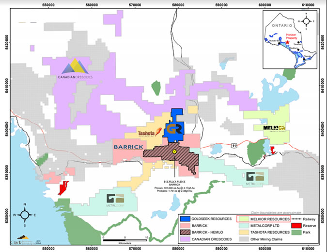
Melkior Resources White Lake Project is comprised of 328 contiguous claim units (12,966 acres), located approximately 15 km northeast of the Hemlo Gold Mine currently operated by Barrick Gold Corporation. The White Lake Property is situated in the north-eastern portion of the Hemlo Greenstone belt, which has only seen sporadic interest in the last four decades, since the Hemlo staking rush. The White Lake Property has only been partially covered by airborne EM surveys (Aerodat Limited, 1989) and subject to multiple Magnetometer, VLF, IP, Spectral IP surveys, geological mapping and soil sampling. Limited trenching, blasting and diamond drilling has been undertaken only on the Kakeeway claim group. This surface work resulted in in the discovery of the high-grade Carroll-MacDougall gold occurrence in the fall of 1993. The Carroll-MacDougall gold occurrence has reported assays of up to 1,168 g/t gold, taken by Resident Geologists with the Ontario Geological Survey. In June 2017 Melkior made a site visit to the Carroll-MacDougall gold occurrence, samples were taken and confirmed its gold bearing nature with values up to 19.2 g/t gold. The structure hosting the Carroll-MacDougall gold occurrence is parallel to and within one meter of a transition from mafic to felsic volcanic rock. This contact zone has been reported to be auriferous over about 100 meters.
Melkior is primarily targeting “Hemlo Style” mineralization and as such priority targets are expected to have an EM signature. The available information suggests that disseminated/chargeable sulphide mineralization are present within a favorable geological setting on the White Lake Project. However, the same information also suggests that it likely does not extend to the surface. The on-site surface gold showings identified to date likely represent leakage from a deeper mineralized source. Geotech reports “… the VTEM data shows several discrete EM anomalies in the White Lake Project area. The TAU images show a collection of conductive bodies in the southern portion of the block. These are associated with high magnetic gradient areas. According to the resistivity depth images, they lie with their tops around 100m from surface.”
Melkiors claim units cover the southeastern extension of the North Limb of the Hemlo Greenstone Belt to the limit of a Provincial Alienation. A geological compilation map (Map 2614, Muir, T.L. 2000) indicates the greenstone belt strikes NW-SE and that a gold occurrence is present on Melkiors claim group close to the southern boundary. Further to the NW of this gold occurrence are two molybdenum occurrences. In the Hemlo Area there is a strong positive correlation between molybdenum and gold mineralization. The map also indicates a group of gold molybdenum occurrences on strike and within the greenstone belt about 500m south within the alienation. The linear trend of gold and molybdenum showings in the southeastern portion of the claim group and along strike of the Kakeeway Claims reinforces Melkiors belief that the area merits additional exploration.
Historical exploration data, available through the MNDN, has been amalgamated and reviewed. At least five soil sampling surveys have been conducted over parts of the current claim group. There appears to be some consistent anomalous gold trends that persist and are co-located with VLF trends and IP chargeability trends. The review reinforces the concept that there may be a gold mineralized zone within the Hemlo Greenstone Belt where it traverses Melkiors claim group.
- 2019 Exploration Details
- 2018 Exploration Details and Target Write-Up