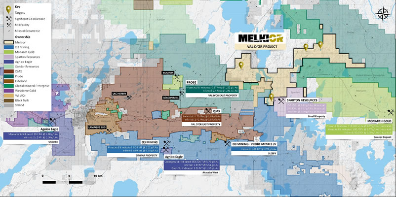
The Val-d’Or Property is located 35km east from Val d’Or and is accessible by a well-maintained dirt road as well as logging roads. The 120 claims cover approximately 6,333.04 hectares (63.33km2) and currently have over $340,000 in exploration reserve credits and no restrictions on these claims.
Multiple gold and copper showings are present on and around the Property. The Property covers the Lac Poisson-Nord showing, which encountered 1.0g/t over 1.5m. The mineralization consisted of carbonate and quartz veins hosted in a silicified granodiorite. Multiple gold showings are located on the adjacent properties, in the same granodiorite unit.
The Geoffroy copper showing, located south of the western part, located on the Globex Mining claims returned up to 9.90% Zn, 9.75% Cu and 98.4g/t Ag over 0.64m; 2.56% Cu, 0.11% Zn and 14.0g/t Ag over 0.91m; and 3.56% Zn, 0.86% Cu and 8.6g/t Ag over 0.88m in three different holes. The mineralization is composed of sulfides horizon hosted in intermediate pyroclastic and mafic volcanic rocks of the Kinojevis Group. They are intersected by porphyric sills and dykes.
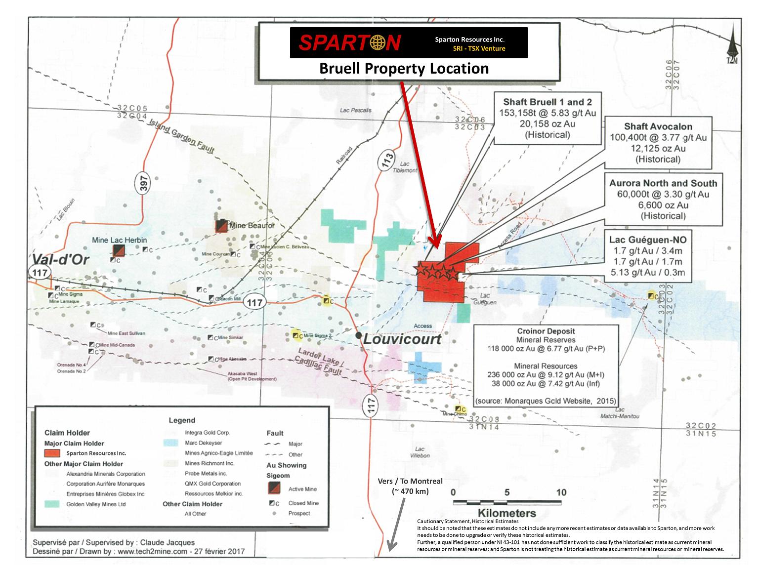
The other adjacent showings include those being worked by Sparton to the south. The mineralization shows lateral continuity over 250m in the drilling they have performed. Melkior’s claims cover volcanic rocks, the same geological formation that contains the quartz veins and shear zones that include the mineralization in these showings. The historical mineshaft of the Bruel mine, owned by Sparton, is located 150m east of the Property’s limit. The new discovery by Sparton is located 600m east in the same direction. The regional magnetic anomalies associated with the gold mineralization also extend onto the Property, further indicating that the volcanic unit is found on the Property.
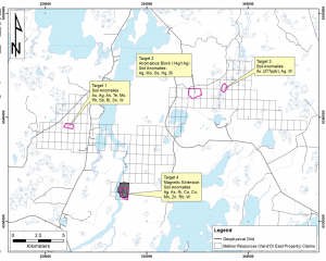
The Company’s top priority target is Target 4, located in the southern area of the Property. The target is based on soil anomalies that indicate a possible source located up-ice, on the Property. Target 4’s lithologies include basalts and mafic volcanoclastic rocks; a 1km long formation that is locally described as a cherteous tuf with semi-massive sulfide pockets; and a tonalite-granodiorite intrusion. The tonalite-granodiorite intrusion is most likely the source of 4 mineralized showings located as close as 300m outside of the Property, including the Bruell Deposit, on the neighboring Eldorado/Sparton joint venture.
The anomaly is multi-elemental (Ag, As, Ni, Co, Cu, Mo, Zn, Rb, and W) and could be associated with gold and base metal mineralization. Its source is expected to be located on strike with the Bruell showing and is also on strike with additional discoveries made by Sparton Resources (http://www.spartonres.ca/wp-content/uploads/2017/08/Sparton-Bruell.jpg). The Bruell showing is part of multiple mineralizations that include 4 gold showings located less than 150m east, on strike of the soil anomaly’s suspected source. This local context, the historical magnetic airborne survey, and the soil anomalies support this specific area being investigated by an IP survey which is underway.
Target 1 is situated in the western area of the Property and could be an anomaly associated with intrusion-related gold mineralization. This target is generated using multiple soil samples that are anomalous in different elements including: Au, Ag, As, Te, Mo, Pb, Sb, Bi, Sn, and W. The Company has added 13 new claims (746.2 ha) to the Property to make sure it covers the potential source of this anomaly. The source is expected to come from the granodiorites located just north of that area, and the unit already includes gold showing in similar geological context to what is expected to be the source of the anomaly (the Jenson showing is grading at 6.7 g/t Au and is hosted in intrusions, approximately 3-4km NE of the anomaly and outside of the Property).
Target 2 could be the source of an anomalous area in gold that is located in the northern part of the Property and is spatially close to 0.45 oz per ton of silver assayed in a metric sized boulder. The 2m x 1m boulder indicates that the source of the anomaly may be located close-by to the boulder. The target also includes anomalies in Mo, Se, Hg and Bi.
Target 3 is related to a high gold anomaly (277 ppb Au) in till and is located in the North-East area of the Property. This anomaly is also associated with Ag and W. The Company has multiple claims up-ice from the anomaly and will further inspect the suspected source of the anomaly.